
See Land the Way Professionals Do
Parcel ID transforms how you view property data by overlaying parcel lines and traffic counts on stunning aerial imagery. Experience a new dimension of land analysis with our intuitive GIS service.
How Parcel ID Integrates with Google Earth Pro
Parcel ID overlays parcel lines, ownership records, and traffic data directly into Google Earth Pro giving you a powerful, intuitive mapping experience for commercial real estate analysis.

Built to Integrate with Your Workflow
Parcel ID works directly within Google Earth Pro, so there’s nothing new to learn, just launch and locate your property of interest.
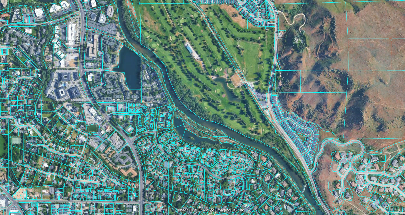
Intuitive Parcel Overlay and Ownership Insights
Quickly overlay parcel boundaries, property data, and zoning files, seamlessly layered onto Google Earth Pro's aerial imagery.

Real-Time Traffic Intelligence at a Glance
Visualize traffic volume trends and street-level movement to guide development decisions with confidence.
"As a broker, I rely on Parcel ID daily to evaluate properties, understand frontage and access, and to be able to provide clients with valuable insights. It streamlines my workflow and reduces the time I spend researching potential development sites.

"Working statewide, Parcel ID has become an essential tool in my appraisal process. Having instant access to parcel boundaries across Idaho saves time on every report"

""At our firm, both agents and support staff rely on Parcel ID every day. It has become a core part of how we evaluate sites and present opportunities to clients. Parcel ID combines county information with the speed, convenience, and many features of Google Earth."

Built for Investors, Developers, and Decision-Makers
Experience unparalleled property analysis with Parcel ID. Make informed decisions faster and more efficiently.
Enhanced Analysis
Gain deeper insights into property values and trends with our advanced mapping tools.
Time Savings
Streamline your workflow and reduce time spent on property research and analysis.

FAQs
Discover answers to common questions about Parcel ID and how our services can help you.
Parcel ID is a GIS service that provides detailed parcel data overlaid on aerial imagery. It allows users to visualize parcel lines and traffic counts effectively. This tool is integrated within Google Earth Pro for enhanced accessibility.
Parcel ID overlays parcel lines and relevant data onto high-resolution aerial images. Users can interact with the map to get insights into property boundaries and traffic patterns. This functionality is designed to support urban planning and real estate analysis.
Parcel ID is beneficial for urban planners, real estate professionals, and local government officials. It provides essential data for making informed decisions regarding land use and development. Anyone interested in geographic data can utilize this service.
Yes, Parcel ID is designed with user experience in mind. The interface is intuitive, making it easy for users to navigate and access data. Comprehensive support and resources are also available to assist users.
Getting started with Parcel ID is simple. You can sign up for an account on our website and access the service immediately. Explore our tutorials and guides to maximize your experience.
Chosen by innovators and professionals

Unlock Your Parcel Insights Today
Discover how Parcel ID can transform your property analysis with our intuitive GIS tools. Start your journey towards smarter decisions and enhanced visibility now!